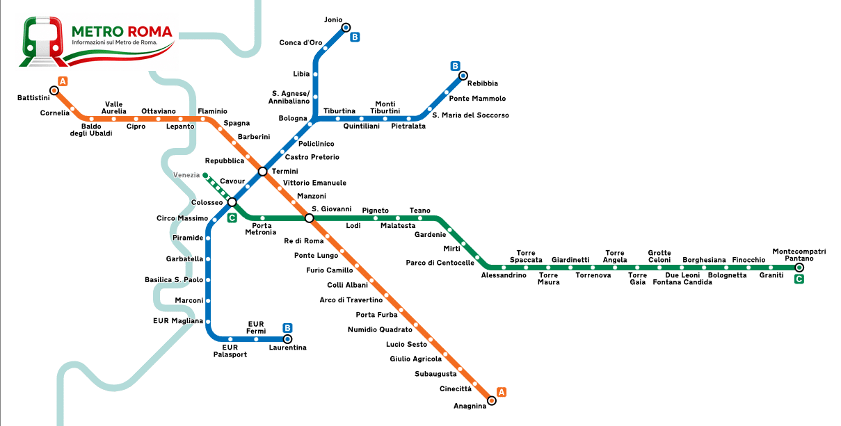
Rome Metro Map
The complete Rome Metro network—Lines A, B/B1, and C, including all stations and transfer points. Download the map below.
Information updated: October 2026
The Rome Metro Network
Map of the Rome Metro (Lines A, B/B1, and C). For real-time updates and announcements, always check the official channels ATAC.
The lines
Line A
Battistini ↔ Anagnina
27 stations · Rome Metro
BLine B
Laurentina ↔ Rebibbia
22 stations · Rome Metro
C Line C
Monte Compatri/Pantano ↔ Colosseo
24 stations · Rome Metro
B1 Line B1
Laurentina ↔ Jonio
19 stations · Rome Metro
Have you seen the map? Now calculate your route
The map shows the lines; our calculator does the rest. Enter your starting point and destination to get the exact stations, transfers, and travel time.
Plan your routeThe network in numbers
| Line | Stops | End to end | Weekday trips |
|---|---|---|---|
| ABattistini ↔ Anagnina | 27 | 41 min | 556 |
| BLaurentina ↔ Rebibbia | 22 | 39 min | 242 |
| B1Laurentina ↔ Jonio | 19 | 39 min | 240 |
| CMonte Compatri/Pantano ↔ Colosseo | 24 | 38 min | 231 |
Stops, times and trips taken from Atac's official GTFS. The four rows add up to 77 stops because Termini, San Giovanni and Colosseo belong to two lines each: the network has 74 distinct stations.
What the map does not show
The regional railways
The Roma-Lido (branded Metromare, for Ostia and the coast) and the Roma-Viterbo are not the metro, and since 2022 Atac no longer runs them: the infrastructure belongs to ASTRAL and the service to Cotral. Metrebus tickets are still valid on the urban stretch, but frequencies differ and they are not in the route planner. The Termini-Centocelle closed in 2026 and is replaced by buses.
The airports
No metro line reaches Fiumicino or Ciampino. For Fiumicino take the Leonardo Express from Termini; for Ciampino there are coaches from Termini and a link via Ciampino railway station. Check times and operator before you travel: they change often.
Trams and buses
The surface network is far denser than the metro and covers the areas without it. Every station page lists the routes stopping within 250 metres.
Stations closed for works
The map shows the network as designed. Temporary closures are in Works and service updates, each with its date.